MapmyIndiaΓÇÖs version 7.1 maps ΓÇô IndiaΓÇÖs most comprehensive, exhaustive, detailed and updated map coverage ΓÇô provide first- and best-in-class advanced navigation and driver assistance features with visual cues, such as: ΓÇóExtended lane guidance (telling the user which lane to get into prior to a turn or exit)

ΓÇóJunction views (how the upcoming intersection looks in real-life)

ΓÇóSign-posts (which major landmarks, localities and cities lie in the direction of upcoming turns)

ΓÇóDay-time based turn restrictions (based on time and day, whether the particular road is 2-way or one-way in a particular directions)

ΓÇóLive traffic (what is the live congestion on roads in the city)
MapmyIndia continues to offer the most localized navigation experience, with city guides and rich points of interest (which provide detailed descriptions and photographs of places to visit, stay, eat and shop in popular tourist destinations and cities) voice guidance in 9 regional languages and is also introducing regional maps in 4 local languages (which displays the map in the regional language), to aid users who prefer to communicate and interact with the navigation systems in local Indian languages and not just English.

MapmyIndiaΓÇÖs GPS navigation system enables accurate turn-by-turn voice-guided navigation to the building doorstep, not just a nearby landmark or the general locality. The version 7.1 MapmyIndia maps continue to provide best-in-class full 3D coverage of India, with digital elevation models and terrain across India, thousands of full-scale 3D landmarks across India, which offer life-like 360-degree views of popular tourist and commercial landmarks, and full 3D city models containing 3D buildings in residential and commercial areas for 36 major cities across India, including all the major metropolitan areas.
Overview Let us be your guide in one of the two most cycle-friendly countries — Belgium and Luxembourg — with the most versatile outdoor topographic map data available.
Provides 1:25,000 - 1:50,000 data from the national geographic institutes database
Displays elevation contours every 2-3 meters, building footprints and Digital Elevation Model (DEM) for 3-D profiling
Shows searchable geographic places, touristic points of interest and road addresses
New ActiveRouting¹ functionalities offer tailored and innovative outdoor routing, named trail routing and optimized map layouts — perfect for easy tour planning
¹ActiveRouting supported by BaseCamp™ on Windows®/Mac® and Montana®, GPSMAP® 62, 78, Edge 810, and Oregon® x50, 6x0 devices.
Coverage Features topographic coverage of Belgium and Luxembourg.
Garmin - City Navigator Southern Africa NT 2014.30 Requirements: garmin devices Overview: Navigate the streets with confidence. This product provides detailed road maps and points of interest for your device, so you can navigate with exact, turn-by-turn directions to any address or intersection.
Includes more than 1.04 million km (649,000 mi) of roads, including motorways, national and regional thoroughfares and local roads, in South Africa. Displays more than 330,000 points of interest throughout the country, including restaurants, petrol/gasoline stations, lodging, attractions and railways. Gives turn-by-turn directions on compatible devices. Speaks street names (example: "Turn right on Main Street"). Includes navigational features, such as turn restrictions, roundabout guidance and speed categories. Contains traffic data for compatible devices that use traffic receivers.
Features coverage of Angola, Botswana, Lesotho, Malawi, Mozambique, Namibia, Swaziland and Zimbabwe, with detailed coverage throughout the Republic of South Africa
FID 3125
в архиве: unlocked gmap folder unlocked 3d jcv file
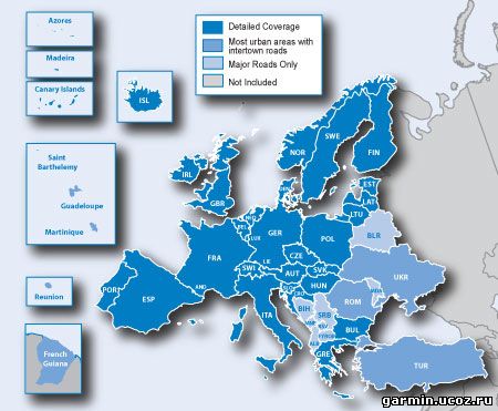
Дата выпуска: 08.2013 Версия: 2014.20 Разработчик: Garmin Сайт разработчика: garmin.com Язык интерфейса: Английский Ключ: Не требуется. (Карта разблокирована) Системные требования: Навигаторы Garmin Зона покрытия: North America FID: 3047 Описание: Включает в себя покрытие из США, Канады и Мексики, включая Пуэрто-Рико, Американские Виргинские острова, Каймановы острова и Багамы. Также содержит новый дополнительный охват Французская Гвиана, Гваделупа, Мартиника и Сен-Бартельми. Обеспечивает более 6,5 миллионов точек интереса, включая гостиницы, рестораны, парковки, развлекательные, топлива и магазинов. Включает в себя магистрали, между штатами, а также деловых и жилых дорог в городских и сельских районов. Включает в свою очередь ограничения, окольными руководства, скорость категорий.
Navigate the streets with confidence. This product provides detailed road maps and points of interest for your device, so you can navigate with exact, turn-by-turn directions to any address or intersection.
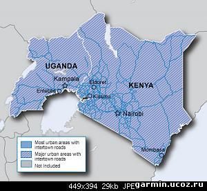
Includes more than 127,300 mi (205,000 km) of roads, including motorways, national and regional thoroughfares and local roads, in Eastern Africa.
Displays more than 54,600 points of interest throughout the continent, including restaurants, lodging, petrol/gasoline stations, attractions and railways.
Gives turn-by-turn directions on compatible devices.
Speaks street names (example: "Turn right on Main Street").
Includes navigational features, such as turn restrictions, roundabout guidance and speed categories.
Contains traffic data for compatible devices that use traffic receivers.
Coverage Features motorways, national and regional thoroughfares and local roads, in Eastern Africa, specifically:
Дата выпуска: 2013.09 Версия: 14.20 Язык интерфейса: Мультиязычный (русский присутствует) Ключ: Не требуется. (Карта разблокирована) Системные требования: MS Windows Описание: Garmin City Navigator Europe NTU 2014.20 UNLOCKED 2D и 3D gmapsupp.img - Разблокированная Карта Европпы gmap3d.img - Разблокированная Карта Европпы (3D Здания) Я файл gmapsupp.img положил на SD карточку в папку Garmin для приборов поддерживающих только 2D карты этого должно быть достаточно. Файл gmap3d.img запихнул на прибор в папку Map
Дата выпуска: 2013 Язык интерфейса: Русский Ключ: Не требуется. (Карта разблокирована) Системные требования: Навигатор Garmin 21 мегабайт свободного места Зона покрытия: Полуостров Крым FID: 1954 Описание: 1. Добавлено около 1000 километров лесных дорог и троп. 2. На многих участках карты уточнены контуры леса, прорисованы поляны, скальные выходы. 3. В дополнение к туристическим маршрутам, обозначенным номерами согласно постановлению №160 от 12 апреля 2005 года, нанесены промаркированные маршруты в соответствии с информацией КСС Поиск опорных точек промаркированного маршрута осуществляется по слову соответствующему цвету маркировки, например "синий". 4. В целях возрождения исторических и культурных традиций, в Крым Навигатор 2013.1 включены материалы опубликованные на карте И. Л. Белянского, которую нам любезно предоставила научная библиотека "Таврика" Центрального музея Тавриды.
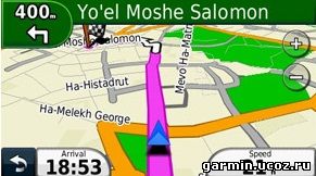
Год выпуска: 2013 Версия: 2014.30 Совместимость с Vista: неизвестно Язык интерфейса: только английский Таблэтка: Не требуется Описание: Полностью маршрутизируемая карта Израиля для загрузки в приборы Garmin (gmapsupp.img разлочен). Карта существенно отличается в лучшую сторону от известной карты Israel Routable NT 1.64.
Нанесено большое кол-во мелких поселений, более 60 тысяч POI.
 Overview
 Garmin - City Navigator Southern Africa NT 2014.30
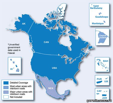

 Карта Турции для Гармин, FID: 4604