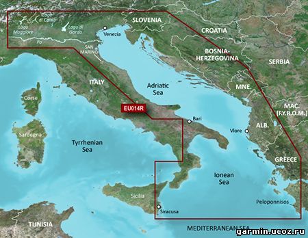
AutoDrive Hellas is a detailed road map especially designed for Garmin navigation devices. Its unbeatable coverage in conjunction with regular updates make it the most comprehensive solution for navigation in Greece, both within and outside the city. It is the only map that combines detailed coverage of cities and villages throughout Greece, with information on dirt roads, mountain peaks, beaches.
Includes Athens greater area, Piraeus and Thessaloniki, all Prefectures capitals, and all settlements (cities/towns/villages) of Greece.
412,000 kilometers of navigable road network and 12,500 settlements.
41,000 feature names (e.g. mountain tops, harbours, bights, gulfs etc.) as well as all hydrological network (rivers, lakes, fountains)
Many additional points of interest in these general categories: Sports, Transit-Trains-Tram-Metro, Airports, Harbours, Neighborhoods, Community Services, Entertainment, Education, Food, Parks-Squares, Places of Worship, Private Enterprises, Institutions, Hotels, Beaches, Tourism, Recreation, Health
See your vessel’s precise, on-chart position in relation to navaids, coastal features and restricted areas with premium features found in this detailed marine mapping data. Includes all of the features of our BlueChart® g2 product, plus 3-D perspective above and below the waterline, Auto Guidance, high-resolution imagery, and aerial photos of ports, harbors, marinas and landmarks.
Shaded depth contours, coastlines, spot soundings, navaids, port plans, wrecks, obstructions, intertidal zones, restricted areas and IALA symbols.
Seamless transitions between zoom levels and more continuity across chart boundaries.
High resolution satellite imagery for a realistic view of the land and water.
Aerial photos of ports, harbors, marinas, waterways, navigational landmarks and other POIs.
Auto Guidance technology searches chart data to suggest the best passage to a destination.
MarinerEye view 3-D perspective for a quick, easy position fix.
FishEye view 3-D perspective for an underwater view of the sea floor.
Safety Shading* enables contour shading for all depth contours shallower than your defined safe depths.
Fishing Charts* to scope out bottom contours and depth soundings with less visual clutter on the display.
Plan and organize routes from your computer with HomePort™ (sold separately).
Azoknak, akik előre programozott SD kártyán, a megvásárolt GPS készülékkel együtt kapták a magyar térképet.
Töltse le a fájlt, majd csomagolja ki egy ideiglenes mappába a számítógépen!
Ellenőrizze a NaviGuide Magyarország SD kártyáján az írásvédelmi kapcsolót a kártya oldalán, az az érintkezők irányába álljon!
Helyezze be a NaviGuide-ot tartalmazó SD kártyát a számítógéphez csatlakoztatott kártyaolvasóba! A nüvi, zumo, StreetPilot c5XX készülék is használható kártyaolvasóként. Fontos, hogy a számítógépre csatlakoztatott Garmin készülék kettő meghajtóként jelenik meg. Az SD kártya olvasó - operációs rendszertől függően - "Cserélhető lemezes meghajtó"-ként jelenik meg (nem a "Garmin" vagy "nuvi" vagy "zumo" meghajtó), ebben kell megkeresni a Garmin mappát és az említett állományt.
Másolja át az SD kártyára a "gmapsupp.img" nevű fájlt az ott található, ugyanilyen nevű fájl felülírásával!
Az új térkép telepítése után ajánlott a GPS készülék szoftverét is megfrissíteni a WebUpdater alkalmazással!
Figyelem! Ez a frissítés csak azzal az SD kártyás Magyarország térképpel használható, amelyiken a \Garmin mappában megtalálható egy "gmapsupp.unl" nevű fájl is! Régebbi kártyákon nincs ilyen fájl, és azokon a friss térkép nem működik. Kérjük forduljon ügyfélszolgálatunkhoz segítségért!
See your vessel’s precise, on-chart position in relation to navaids, coastal features and restricted areas with premium features found in this detailed marine mapping data. Includes all of the features of our BlueChart® g2 product, plus 3-D perspective above and below the waterline, Auto Guidance, high-resolution imagery, and aerial photos of ports, harbors, marinas and landmarks.
Shaded depth contours, coastlines, spot soundings, navaids, port plans, wrecks, obstructions, intertidal zones, restricted areas and IALA symbols.
Seamless transitions between zoom levels and more continuity across chart boundaries.
High resolution satellite imagery for a realistic view of the land and water.
Aerial photos of ports, harbors, marinas, waterways, navigational landmarks and other POIs.
Auto Guidance technology searches chart data to suggest the best passage to a destination.
MarinerEye view 3-D perspective for a quick, easy position fix.
FishEye view 3-D perspective for an underwater view of the sea floor.
Safety Shading* enables contour shading for all depth contours shallower than your defined safe depths.
Fishing Charts* to scope out bottom contours and depth soundings with less visual clutter on the display.
Plan and organize routes from your computer with HomePort™ (sold separately).
See your vessel’s precise, on-chart position in relation to navaids, coastal features, anchorages, obstructions, waterways, restricted areas and more with this detailed marine mapping data.
Shaded depth contours, coastlines, spot soundings, navaids, port plans, wrecks, obstructions, intertidal zones, restricted areas and IALA symbols.
Seamless transitions between zoom levels and more continuity across chart boundaries.
Standard 2-D direct overhead or 3-D "over the bow” map perspective for easy chart reading and orientation.
Safety Shading* enables contour shading for all depth contours shallower than your defined safe depths.
Fishing Charts* to scope out bottom contours and depth soundings with less visual clutter on the display.
Plan and organize routes from your computer with HomePort™ (sold separately).
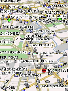
Подробная карта Индонезии для программы GPS навигации Навител Навигатор. Показано побережье страны, населённые пункты, множество точек интереса. Поддерживается адресный поиск с точностью «до улицы».
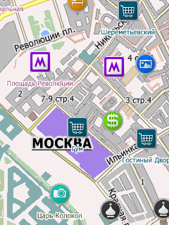
Официальная карта Москвы для программы GPS навигации City Guide. Нанесены названия улиц и номера домов, множество точек интереса. Поддерживается пробочный сервис.
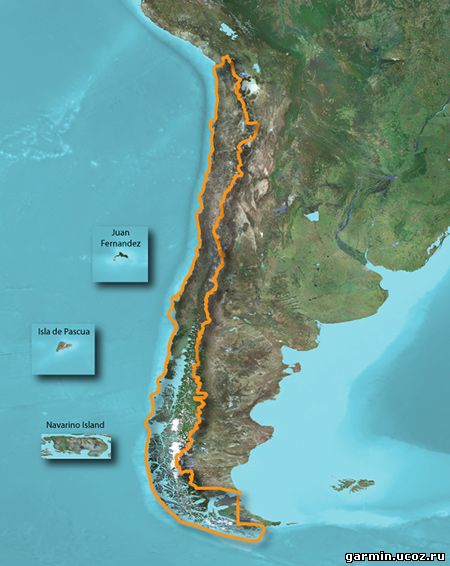
Descripción: Déjanos ser tu guía para actividades al aire libre en Chile. Estos mapas topográficos detallados muestran callejeros y mapas de ocio para actividades al aire libre, incluyendo contornos del terreno, elevaciones topográficas, cumbres, parques, líneas de costa, ríos, lagos, puntos geográficos y mucho más.
Proporciona mapas topográficos detallados para senderismo, excursionismo, ciclismo y otras actividades al aire libre.
Muestra contenido de carreteras con rutas e incluye indicaciones giro a giro.
Incluye una base de datos de puntos de interés, así como información sobre parques nacionales, senderos y caminos, lagos, ríos y arroyos.
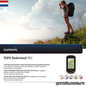
Garmin TOPO Nederland v.2 PRO Requirements: Compatible with Garmin GPS, PC Overview: Let us be your guide in one of the most cycle-friendly countries — the Netherlands — with the most versatile outdoor topographic map data available.
Provides 1:25,000 - 1:50,000 data from the National Geographic Institutes database Displays elevation contours every 2-3 meters, building footprints and Digital Elevation Model (DEM) for 3-D profiling Shows searchable geographic places, touristic points of interest and road addresses New ActiveRouting¹ functionalities offer tailored and innovative outdoor routing, named trail routing and optimized map layouts — perfect for easy tour planning
¹ActiveRouting supported by BaseCamp™ on Windows®/Mac® and Montana®, GPSMAP® 62, 78, Edge 810, and Oregon® x50, 6x0 devices.

 Garmin TOPO Nederland v.2 PRO


