Год выпуска: 2014
Версия: 2015.20
Разработчик: Garmin
Платформа: Garmin
Совместимость с Vista: нет
Системные требования: Платформа Garmin
Язык Русский
Описание:
Уведомление улиц и имен в Кириллическим шрифтом.Перемещайтесь по улицам России с уверенностью. City Navigator Russia NT содержит подробные дорожные карты и POI для вашего устройства Garmin, так что вы можете перемещаться с точным указаниями направления по любому адресу или перекрестку. Маршрут до ресторанов, заправочных станций, жилья, достопримечательностей и многое другое
Дата выпуска: 2014 Версия: 15.10 Язык интерфейса: Мультиязычный (русский присутствует) Ключ: Не требуется. (Карта разблокирована) Системные требования: MS Windows Описание: Garmin City Navigator Europe NT 2015.10
Дата выпуска: 06.05.2014 Версия: 4.8 Разработчик: картаБиБи Сайт разработчика: http://kartaby.by Язык интерфейса: Русский Ключ: Не требуется. (Карта бесплатная) Системные требования: Garmin Зона покрытия: почти 100% РБ FID: 375 Описание: Команда проекта "Дороги Беларуси" рада сообщить - выпущен очередной релиз карты Республики Беларусь для навигаторов фирмы Garmin. Были учтены и внесены все Ваши замечания и дополнения. Обновлена карта многих городов, актуализирован дорожный роутинг согласно ПДД, открыт проспект Держинского в Минске , нанесены новостройки во многих городах. Добавлены многие тысячи точечной адресации и POI. Протяженность дорожного графа составляет более 296 тысяч км. Доп. информация: В связи с введением оплаты за проезд по некоторых дорогах Республики Беларусь, Гражданам, передвигающимся на транспортных средствах зарегистрированных в Таможенном Союзе, для правильной прокладки роута убрать в настройках "Избегать платных дорог".
See your vessel’s precise, on-chart position in relation to navaids, coastal features, anchorages, obstructions, waterways, restricted areas and more with this detailed marine mapping data.
Shaded depth contours, coastlines, spot soundings, navaids, port plans, wrecks, obstructions, intertidal zones, restricted areas and IALA symbols.
Seamless transitions between zoom levels and more continuity across chart boundaries.
Standard 2-D direct overhead or 3-D “over the bow” map perspective for easy chart reading and orientation.
Safety Shading* enables contour shading for all depth contours shallower than your defined safe depths.
Fishing Charts* to scope out bottom contours and depth soundings with less visual clutter on the display.
Plan and organize routes from your computer with HomePort™ (sold separately).
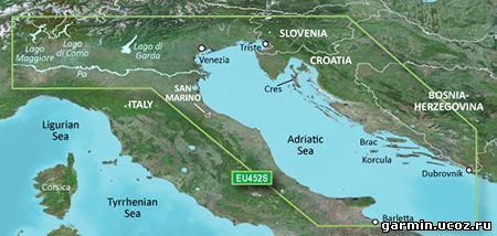
Coverage Detailed coverage of the Adriatic Sea coast from Trani to Monfalcone, IT southeast to Dubrovnik, HR. Includes detailed coverage of Lago Maggiore, Lago di Como, Lago d'Iseo, Lago di Garda and the Po River from the Adriatic to the Ticino River confluence.
See your vessel’s precise, on-chart position in relation to navaids, coastal features, anchorages, obstructions, waterways, restricted areas and more with this detailed marine mapping data.
Shaded depth contours, coastlines, spot soundings, navaids, port plans, wrecks, obstructions, intertidal zones, restricted areas and IALA symbols.
Seamless transitions between zoom levels and more continuity across chart boundaries.
Standard 2-D direct overhead or 3-D “over the bow” map perspective for easy chart reading and orientation.
Safety Shading* enables contour shading for all depth contours shallower than your defined safe depths.
Fishing Charts* to scope out bottom contours and depth soundings with less visual clutter on the display.
Plan and organize routes from your computer with HomePort™ (sold separately).
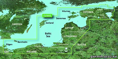
Coverage Coverage of the coasts of Germany, Poland, Russia, Lithuania, Latvia and Estonia from Rügen, DE to Narva-Jõesuu, EE. Detailed coverage includes the Szczecin Lagoon, Bornholm, the Vistula Lagoon, Kaliningrad, Gotland, the Gulf of Riga, Saaremaa, Hiiumaa, Lake Peipus, and the Mazurian and other Polish lakes including Lake Jeziorak, Lake Lanskie and Lake Sniardwy.
See your vessel’s precise, on-chart position in relation to navaids, coastal features, anchorages, obstructions, waterways, restricted areas and more with this detailed marine mapping data.
Shaded depth contours, coastlines, spot soundings, navaids, port plans, wrecks, obstructions, intertidal zones, restricted areas and IALA symbols.
Seamless transitions between zoom levels and more continuity across chart boundaries.
Standard 2-D direct overhead or 3-D "over the bow” map perspective for easy chart reading and orientation.
Safety Shading enables contour shading for all depth contours shallower than your defined safe depths.
Fishing Charts to scope out bottom contours and depth soundings with less visual clutter on the display.
Plan and organize routes from your computer with HomePort™ (sold separately).
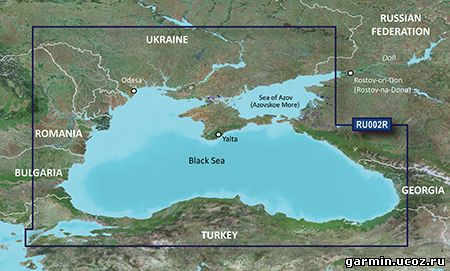
Coverage Coverage of the Dardanelles, the Sea of Mamara, the Bosporus, the Black Sea, the Dnieper River as far as Kherson, the Bug River as far as Nikolayev and the Sea of Azov.
Detailed coverage includes Burgas and Varna, Bulgaria; Constanta, Romania; Odessa, Nikolayev, Kherson, Sevastopol', Kerch' and Mariupol, Ukraine; Taganrog, Yeysk, Temryuk, Novorossiysk, Poti and Batumi, Russia; Hopa, Giresun, Samsun, Zonguldak, Eregli, Istanbul, Bandirma and Canakkale, Turkey. FID: 3247, PID: 1, RID: 17, VID: 3
Тип раздаваемого файла: Карта Формат: .IMG FID: 575 Платформа: Garmin Версия: 2013.06 Дата выпуска: март 2014 Разработчик: ООО «Карт Бланш Украина» Офсайт:http://www.gpsmap.com.ua/ru/products/software/cbunt/ Язык интерфейса: украинский, русский и английский Лицензия: карта разблокирована
See your vessel’s precise, on-chart position in relation to navaids, coastal features, anchorages, obstructions, waterways, restricted areas and more with this detailed marine mapping data.
Shaded depth contours, coastlines, spot soundings, navaids, port plans, wrecks, obstructions, intertidal zones, restricted areas and IALA symbols.
Seamless transitions between zoom levels and more continuity across chart boundaries.
Standard 2-D direct overhead or 3-D “over the bow” map perspective for easy chart reading and orientation.
Safety Shading* enables contour shading for all depth contours shallower than your defined safe depths.
Fishing Charts* to scope out bottom contours and depth soundings with less visual clutter on the display.
Plan and organize routes from your computer with HomePort™ (sold separately).
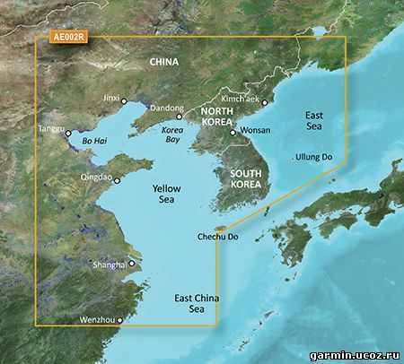
Coverage General coverage of the Chinese coast from Wenzhou to Dandong; the South Korean coast in its entirety; the full west coast of North Korea and the east coast south of Kimch'aek. Included in this overall general coverage are numerous detailed charts covering areas in China such as Shanghai, Qingdao, and Dalian; and also Nampo, N.Kor., and Pusan, S. Kor
See your vessel’s precise, on-chart position in relation to navaids, coastal features, anchorages, obstructions, waterways, restricted areas and more with this detailed marine mapping data.
Shaded depth contours, coastlines, spot soundings, navaids, port plans, wrecks, obstructions, intertidal zones, restricted areas and IALA symbols.
Seamless transitions between zoom levels and more continuity across chart boundaries.
Standard 2-D direct overhead or 3-D “over the bow” map perspective for easy chart reading and orientation.
Safety Shading* enables contour shading for all depth contours shallower than your defined safe depths.
Fishing Charts* to scope out bottom contours and depth soundings with less visual clutter on the display.
Plan and organize routes from your computer with HomePort™ (sold separately).
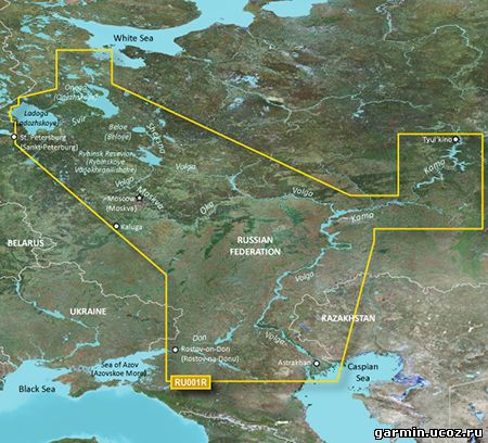
Coverage This Cyrillic data card details main channel coverage of the major river systems and lakes of westernRussia. Detailed coverage includes the Don R. from the Sea of Azov (Azovskoe More) to the Tsimlyanskoe Reservoir (Tsimlyansk Vodokhranilishche); the Volga-Don Canal (Volgo-Donskoy Kanal) to the Volga R. which is shown in its entirety; the Kama R. from Tyul'kino to the Volga R.; the Oka R. from Kaluga to its junction with the Moskva R; the Sheksna R. in its entirety; Lake Beloe (Beloye Ozero); the Volga-Baltic Canal (Volgo-Baltiyskiy Kanal); Lake Onega (Onezhskoe Ozero); the Svir R. to Lake Ladoga (Ladozhskoye Ozero); and the Neva R. to St. Petersburg (Sankt-Peterburg). Also included are the Volga-Baltic Waterway including the Rybinsk Reservoir (Rybinskoye Vodokhranilishche), the entire White Sea-Baltic Canal, Lakes Onega (Onezhskoe), Ladoga (Ladozhskoye), and Beloe (Beloye).
 Год выпуска: 2014
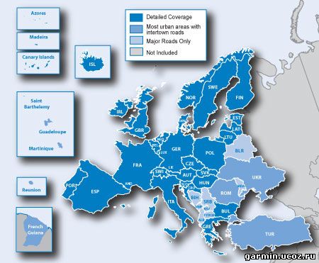

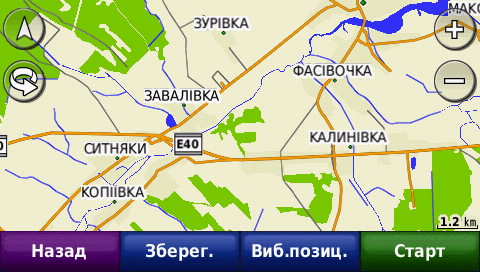
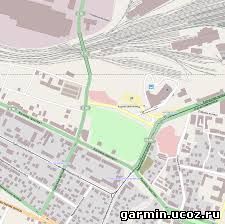 Карта Украины от Open Street Map за 24 апреля данного года. Поиск на украинском языке. Карта разблокирована.