See your vessel’s precise, on-chart position in relation to navaids, coastal features, anchorages, obstructions, waterways, restricted areas and more with this detailed marine mapping data.
Shaded depth contours, coastlines, spot soundings, navaids, port plans, wrecks, obstructions, intertidal zones, restricted areas and IALA symbols.
Seamless transitions between zoom levels and more continuity across chart boundaries.
Standard 2-D direct overhead or 3-D “over the bow” map perspective for easy chart reading and orientation.
Safety Shading* enables contour shading for all depth contours shallower than your defined safe depths.
Fishing Charts* to scope out bottom contours and depth soundings with less visual clutter on the display.
Plan and organize routes from your computer with HomePort™ (sold separately).
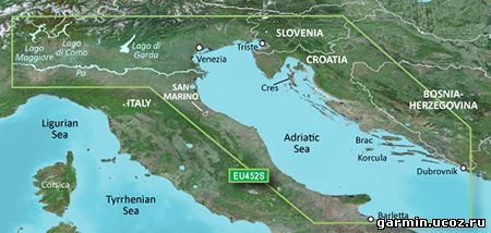
Coverage Detailed coverage of the Adriatic Sea coast from Trani to Monfalcone, IT southeast to Dubrovnik, HR. Includes detailed coverage of Lago Maggiore, Lago di Como, Lago d'Iseo, Lago di Garda and the Po River from the Adriatic to the Ticino River confluence.
See your vessel’s precise, on-chart position in relation to navaids, coastal features, anchorages, obstructions, waterways, restricted areas and more with this detailed marine mapping data.
Shaded depth contours, coastlines, spot soundings, navaids, port plans, wrecks, obstructions, intertidal zones, restricted areas and IALA symbols.
Seamless transitions between zoom levels and more continuity across chart boundaries.
Standard 2-D direct overhead or 3-D “over the bow” map perspective for easy chart reading and orientation.
Safety Shading* enables contour shading for all depth contours shallower than your defined safe depths.
Fishing Charts* to scope out bottom contours and depth soundings with less visual clutter on the display.
Plan and organize routes from your computer with HomePort™ (sold separately).
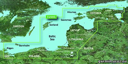
Coverage Coverage of the coasts of Germany, Poland, Russia, Lithuania, Latvia and Estonia from Rügen, DE to Narva-Jõesuu, EE. Detailed coverage includes the Szczecin Lagoon, Bornholm, the Vistula Lagoon, Kaliningrad, Gotland, the Gulf of Riga, Saaremaa, Hiiumaa, Lake Peipus, and the Mazurian and other Polish lakes including Lake Jeziorak, Lake Lanskie and Lake Sniardwy.
See your vessel’s precise, on-chart position in relation to navaids, coastal features, anchorages, obstructions, waterways, restricted areas and more with this detailed marine mapping data.
Shaded depth contours, coastlines, spot soundings, navaids, port plans, wrecks, obstructions, intertidal zones, restricted areas and IALA symbols.
Seamless transitions between zoom levels and more continuity across chart boundaries.
Standard 2-D direct overhead or 3-D “over the bow” map perspective for easy chart reading and orientation.
Safety Shading* enables contour shading for all depth contours shallower than your defined safe depths.
Fishing Charts* to scope out bottom contours and depth soundings with less visual clutter on the display.
Plan and organize routes from your computer with HomePort™ (sold separately).
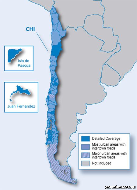
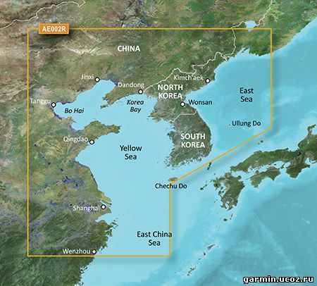
Coverage General coverage of the Chinese coast from Wenzhou to Dandong; the South Korean coast in its entirety; the full west coast of North Korea and the east coast south of Kimch'aek. Included in this overall general coverage are numerous detailed charts covering areas in China such as Shanghai, Qingdao, and Dalian; and also Nampo, N.Kor., and Pusan, S. Kor
Garmin - City Navigator Southern Africa NT 2014.30 Requirements: garmin devices Overview: Navigate the streets with confidence. This product provides detailed road maps and points of interest for your device, so you can navigate with exact, turn-by-turn directions to any address or intersection.
Includes more than 1.04 million km (649,000 mi) of roads, including motorways, national and regional thoroughfares and local roads, in South Africa. Displays more than 330,000 points of interest throughout the country, including restaurants, petrol/gasoline stations, lodging, attractions and railways. Gives turn-by-turn directions on compatible devices. Speaks street names (example: "Turn right on Main Street"). Includes navigational features, such as turn restrictions, roundabout guidance and speed categories. Contains traffic data for compatible devices that use traffic receivers.
Features coverage of Angola, Botswana, Lesotho, Malawi, Mozambique, Namibia, Swaziland and Zimbabwe, with detailed coverage throughout the Republic of South Africa
FID 3337
в архиве: unlocked gmap folder unlocked 3d jcv file
Navigate the streets with confidence. This product provides detailed road maps and points of interest for your device, so you can navigate with exact, turn-by-turn directions to any address or intersection.
Shows more than 168,000 km (105,000 mi) of roads, including motorways, national and regional thoroughfares and local roads.
Displays more than 40,000 points of interest throughout the country, including restaurants, lodging, attractions and shopping.
Gives turn-by-turn directions on compatible devices.
Speaks street names (example: "Turn right on Main Street").
Includes navigational features, such as turn restrictions, roundabout guidance and speed categories.
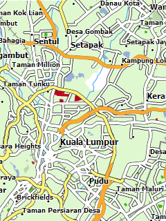
Карта Malsingmaps для GPS навигаторов Garmin, в которую входит карта Малайзии. Нанесены дороги и населённые пункты страны, многочисленные точки интереса, дана карта столицы, города Куала-Лумпур. Доступны поиск по адресу и маршрутизация. В архив с gmapsupp.img включён файл с фото-развязками.
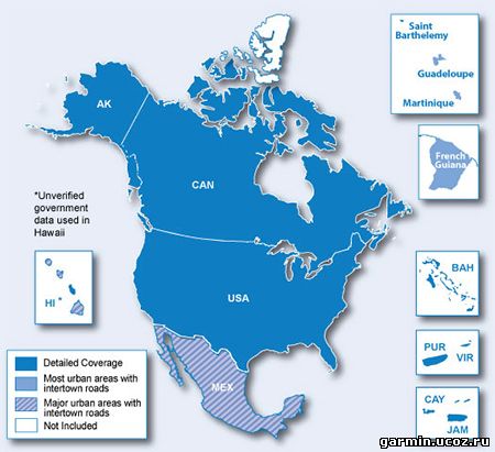
Дата выпуска: 01.2014 Версия: 2014.40 Разработчик: Garmin Сайт разработчика: garmin.com Язык интерфейса: Английский Ключ: Не требуется. (Карта разблокирована) Системные требования: Навигаторы Garmin Зона покрытия: North America FID: 3187 Описание: Включает в себя покрытие из США, Канады и Мексики, включая Пуэрто-Рико, Американские Виргинские острова, Каймановы острова и Багамы. Также содержит новый дополнительный охват Французская Гвиана, Гваделупа, Мартиника и Сен-Бартельми. Обеспечивает более 6,5 миллионов точек интереса, включая гостиницы, рестораны, парковки, развлекательные, топлива и магазинов. Включает в себя магистрали, между штатами, а также деловых и жилых дорог в городских и сельских районов. Включает в свою очередь ограничения, окольными руководства, скорость категорий.
Дата выпуска: 2014 Версия: 1.0 Сборка: www.Garmin.Ucoz.Ru Сайт разработчика:www.Garmin.Ru Язык интерфейса: Русский Ключ: Не требуется. (Карта разблокирована) Зона покрытия: Абхазия Описание:
СборничеГ карт для Абхазия, готовимся к лету - зимой!!!!
Covers the Caribbean from Haiti to Trinidad & Tobago, including Puerto Rico and all of the Lesser Antilles. Also includes the Colombian and Venezuelan coasts from Barranquilla, Colombia to the mouth of the Orinoco River, including Lake Maracaibo and the Gulf of Paria.
Карта глубин побережья Франции с фотографиями, полученными при помощи аэрофотосъемки. Карта включает в себя береговые линии, глубины и изобаты, информацию о навигационной ситуации, судовом ходу и береговой инфраструктуре
 Garmin - City Navigator Southern Africa NT 2014.30