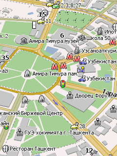
Карта Ташкента с номерами домов для программы GPS навигацииНавител. Нанесены названия улиц, городские достопримечательности, станции метро, гостиницы, банки, учебные заведения, медицинские и государственные учреждения и другие городские объекты. Поддерживается поиск по адресу.
Карта Псковской области для программы GPS навигации Навител Навигатор. Нанесены населенные пункты и дороги области. Также показаны подробные карты городов Псков, Великие Луки, Печоры с номерами домов и большим количеством городских объектов. Нанесено множество POI Псковской области.
Карта Аргентины для программы GPS навигации Навител Навигатор, созданная из данных проекта OpenStreetMap. Показаны населённые пункты, дорожная сеть, водные ресурсы, множество ПОИ. Нанесена карта Буэнос-Айреса с названиями улиц. Поддерживается адресный поиск.
Contains maps of Bulgaria, Romania, Serbia, Macedonia, Greece, Albania, Croatia, Montenegro, Bosnia and Herzegovina and the European part of Turkey.
Bulgaria: Includes maps of 300 cities and resorts, as well as a detailed road network. Romania: the country's road network, Bucharest, Timisoara, Arad, Ploiesti, Constanta, Galati, Braila, Satu Mare, Baia Mare. Serbia: Includes maps of 30 cities, the country's road network. Macedonia: the country's road network, Skopje, Ohrid, Prilep, Bitola. Greece: the country's road network, Athens, Thessaloniki, Larissa, Kavala, Alexandroupoli, Drama, Serres, Komotini, Xanthi,Orestiada. Albania: the country's road network, Tirana, Shkoder, Durres, Elbasan, Vlora, Fier Croatia: the country's road network, Dubrovnik, Split, Rijeka, Zadar, Zagreb, Osijek Montenegro: the country's road network, Podgorica, Tivat, Budva, Tsetinye Bosnia and Herzegovina: the country's road network, Sarajevo, Banja Luka, Mostar, Tuzla, Sanski Most, Prijedor Turkey: road network of the European part, Istanbul.
Карта Болгарии, сконвертированная из карты Garmin BulMaps Balkans, для программы GPS навигации Навител Навигатор. Насесены населённые пункты, дороги, реки, озёра. Во многих населённых пунктах доступен адресный поиск (в основном с точностью до улицы). На карту нанесено более 900000 точек интереса.
Карта Испании, созданная из данных OpenStreetMap, для программы GPS навигации Навител. Показана дорожная сеть страны, населённые пункты, карты крупных городов с названиями улиц и множеством точек интереса.
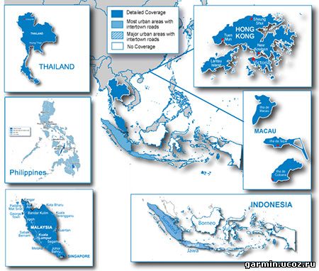
About Coverage Features detailed maps of major metropolitan areas in Singapore, Malaysia, Thailand, Indonesia, Hong Kong, Macau, Philippines, and Bali.
Includes motorways, national and regional thoroughfares and local roads throughout the country. Displays points of interest throughout the country, including restaurants, lodging, attractions, shopping and more. Gives turn-by-turn directions on your compatible device. Speaks street names (example: "Turn right on Main Street") Includes navigational features, such as turn restrictions, roundabout guidance, speed categories and more. Contains traffic data for compatible devices that use traffic receivers.
Карта Эстонии, сконвертированная из данных проекта OpenStreetMap, для программы GPS навигации Навител. Нанесена карта Таллина с номерами домов, но без поддержки адресного поиска, и карты городов Тарту, Нарва также с номерами домов, но с доступным поиском по адресу.
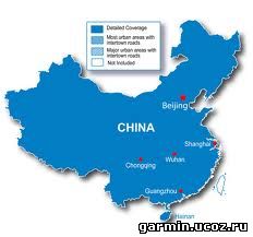
The official Garmin China maps have artificial shift (coordinate deviation) added for national security reasons. Using these maps on normal GPS devices or software will not display your actual location on the map. Instead, you will be a few hundred meters away from your actual location. Only GPS devices and software approved to be sold in the China market have additional built-in firmware or program to use these maps without shift problems. Even so, the saved waypoints, routes, tracks are still shifted. Neither can topo maps be used with them.
Venus is a series of maps derived from the official Garmin China maps but with shifts corrected. Nothing but the coordinates are changed, so all road, POI info, as well as routing, searching capabilities remain intact. Saved waypoints, routes, tracks will have no shift problems. Compatible with topo maps too. These maps can be used on any regular Garmin GPS devices and software as other maps. However, some maps are in Chinese language only and require Chinese support on your device to display and search in Chinese.
Disclaimers: 1. No guarantee or warranty is given. Use at your own risk. 2. The correction is not perfect yet. A few places may have a gap between roads.
For this 2011.12 map: All road and POI names are in simplified Chinese. This map should fix the search problem of 2011.11 map that many users had.
Карта Швеции из данных проекта OpenStreetMap для программы GPS навигации Навител. Нанесены дороги, реки, озёра, населённые пункты страны. Также показана карта Стокгольма и других городов Швеции с названиями улиц и множеством ПОИ. Поддерживается адресный поиск с точностью до населённого пункта.

 Карта Аргентины для программы GPS навигации Навител Навигатор, созданная из данных проекта OpenStreetMap. Показаны населённые пункты, дорожная сеть, водные ресурсы, множество ПОИ. Нанесена карта Буэнос-Айреса с названиями улиц. Поддерживается адресный поиск.