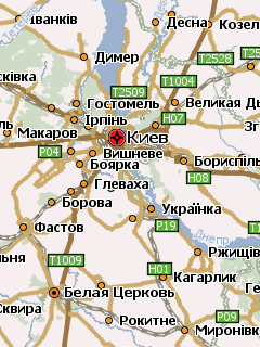
Подробнейший атлас Украины для программы GPS навигации Навител Навигатор. Включает в себя карты областей и городов страны, согласованых для совместной работы друг с другом. Географические название на украинском, кроме Крыма и Донецкой области. Учитывайте это при поиске.
Карта Венгрии для программы GPS навигации Навител Навигатор, созданная из данных OpenStreetMap. Нанесены дороги страны, города и сёла, довольно много точек интереса. Показана карта Будапешта с названиями улиц. Поддерживается поиск населённых пунктов.
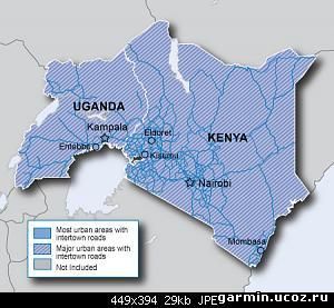
Travel Eastern Africa Navigate the streets of Eastern Africa with confidence. City Navigator Eastern Africa NT provides road maps and points of interest for your Garmin device, so you can navigate with exact, turn-by-turn directions to any address or intersection. Route to restaurants, gas stations, lodging, attractions and more in Kenya, Tanzania, and Uganda. Powered by NAVTEQ, a world leader in premium-quality digital map data.
Features
Includes more than 107,000mi (172,000 km) of road coverage, including motorways, national and regional thoroughfares and local roads, for most urban areas of Kenya, Tanzania, and Uganda.
Includes roads provided by Tracks4Africa.
Features more than 22,500 points of interest, including restaurants, petrol/gasoline stations, lodging, attractions, railways and more.
Gives turn-by-turn directions (on compatible devices) and provides detailed information, such as turn restrictions, roundabout guidance, speed categories and other navigational features.
Discover Great Britain Explore Great Britain's national parksand trails with detailed topographic and road maps. Garmin GB Discoverer National Parks & Trails containstopographic maps from Ordnance Survey of Great Britain including OS Explorer Map as detailed as 1:25,000 scale and 1:50,000 scale Landranger maps for one region of the country. With NAVTEQ road data and points of interest for all of Great Britain, you'll get turn-by-turn directions to your destination.
GB Discoverer's detailed topographic data includes terrain contours, topo elevations, summits, paths, routable roads and geographical points. The premium NAVTEQ road data is the same detailed data included in our leading automotive products — with thousands of addresses and points of interest, including lodging, food and drink, car parks, banks, petrol stations, attractions, campsites, and more. Search for an address or point of interest, and your Garmin device displays turn-by-turn directions to your destination.
Includes topographic coverage of the Lake District.
Provides digital topographic OS Explorer Map as detailed as 1:25,000 scale and 1:50,000 scale Landranger maps for one region of the country.
Includes terrain contours, elevations, summits, trails, trig points, campsites, geographic points and more.
Includes detailed road data and thousands of points of interest from NAVTEQ.
Provides turn-by-turn directions on roads by car or bike.
Allows user to search for destinations by address or by category: points of interest include lodging, food and drink, car parks, banks, petrol stations, attractions, campsitesand more.
Карта Беларуси из данных проекта OpenStreetMap для программы GPS навигации Навител Навигатор. Показаны дороги страны, города, посёлки, деревни, реки, озёра и многое другое. Нанесены карты Минска, Витебска, Гроднос номерами домов и адресным поиском. Частично дома нанесены в городах Гомель и Брест, адресация присутствует и также во многих других, более мелких. Имеется просто огромное количество ПОИ. Отдельные карты городов Беларуси в атласе с этой картой использовать нельзя!
Карта Германии, сконвертированная из данных OpenStreetMap, для программы GPS навигации Навител Навигатор. Неплохая карта, вполне приемлемая детализация, херова база POI и много др. вкусностей, на халяву сойдет.
Карта водных путей Европы для GPS навигаторов Garmin. Сконвертирована из находящихся в бесплатном доступе навигационных карт ENC. Включает в себя водные пути Чехии, Словакии, Австрии, Германии, Болгарии, Румынии, Сербии, Бельгии, Швейцарии, Венгрии, Хорватии, Нидерланд и Франции. Нанесено множество навигационных объектов.
Карта Волгоградской области для программы GPS навигации Навител Навигатор. Показаны города, посёлки и сёла области, дороги, реки, озёра, множество точек интереса. Нанесены карты городов Волгоград, Волжский, Камышин, Жирновск, посёлков Городище, Горьковский с номерами домов и поддержкой адресного поиска.
Карта Таиланда, созданная из данных проекта OpenStreetMap, для программы GPS навигации Навител Навигатор. Показана дорожная сеть страны, населённые пункты, довольно много POI. Поиск поддерживается только по ближайшим.