Дата выпуска: Апрель 2011 Версия: 2012.10 NT Разработчик: Garmin, Navteq Сайт разработчика: https://buy.garmin.com/shop/shop.do?pID=72664 Язык интерфейса: Мультиязычный (русский отсутствует) Ключ: Генерируется пользователем Системные требования: Приборы серий nüvi 1200, nüvi 1300, nüvi 1400 и nüvi 3700. На персональном компьютере программы Garmin Mobile PC или BaseCamp (только с разлоченным вариантом карты)
file structure from garmin DL FYI: *You see 5 different JCV files [for different models & picture sizes] for Full coverage only, in the release there are 20+ different versions for different regions . *2 versions for both ASR/SRX files [for FULL and 1 smaller region], different sizes but with same names *3 versions for G2S [for FULL and 2 smaller region], all different names and sizes *1 version for db [same in all regions], but 2 different files for different models *1 3D, 1 sid & 1 tz file
Changelog: ◦Update 720,000 km. of road data. ◦Update 590,000 points of interest (POIs). ◦Update 900 Junction Views with 37 Complex Junction Views in Bangkok (for compatible devices only). Extra!!! Add 120 Junction Views in Chiang Mai city. ◦Support intersection searching (for compatible devices only). ◦Support text-to-speech (TTS) (for compatible devices only). ◦Add up to 200 3-D buildings in Bangkok and update terrain view for provinces (for compatible devices only). ◦Add and update more than 3,000 CDG Guide data** including categories such as lodging, shopping, attractions, and restaurants. ◦Support searching for car parking lots (for compatible devices only). ◦Update 133,000 telephone numbers (navigable). ◦Support automatic Thai/English map switching or dual map (for compatible devices only). ◦Update more than 5,500 building entry points (Multi-Entry gate). ◦Support traffic report* (for compatible devices only). ◦Update Lane Info for Greater Bangkok and major cities in Thailand. * Coverage area and service's period, quality, and accuracy of traffic report depends on service provider. The company is not responsible for the information
The E32 is the most complete topographic map from the Mexican Republic, specially designed for outdoor activities such as off-road riding, 4x4’s, motorcycle riding, mountain biking, hunting, camping, adventure tourism, professionals with field activities such as (Biologists, Engineers, Geologists and Geographers etc.) or the regular Joe who is taking a trip.
Navigate streets in the Middle East & Northern Africa with confidence. City Navigator Middle East & Northern Africa NT provides detailed road maps for your device and boasts thousands of points of interest throughout the region, so you can navigate with exact, turn-by-turn directions to any address or intersection. Route to restaurants, gas stations, lodging, attractions and more. Powered by NAVTEQ, a world leader in premium-quality digital map data. Includes detailed coverage for major metropolitan areas throughout the Middle East, including Saudi Arabia, United Arab Emirates, Bahrain, Kuwait, Qatar and Oman. Includes coverage for Iraq, Jordan, Egypt, Morocco and Yemen. Provides more than 600,000 km (373,000 mi) of road coverage. Displays more than 550,000 points of interest throughout the region, including restaurants, lodging, attractions, gas stations, shopping and more. Includes motorways, national and regional thoroughfares and local roads. Includes detailed information such as turn restrictions, speed categories and other navigation features.
Gives turn-by-turn directions on your compatible device.
Дата выпуска: 2010 Разработчик: Navteq Сайт разработчика: http://www.garmin.com/garmin/cms/us/maps/cityxplorer Язык интерфейса: Мультиязычный (русский присутствует) Ключ: Генерируется пользователем Системные требования: Garmin Зона покрытия: Столицы и курортные центры FID: Разные Описание: Карты для загрузки в прибор. Только оригинальные (неразлоченные) файлы. Unlock-ер прилагается (в двух вариантах).
Карта Кипра для GPS навигаторов Garmin, сконвертированная из данных OpenStreetMap. Показаны дороги острова, населённые пункты, множество точек интереса. Нанесены карты Никосии, Ларнаки и других городов с названиями улиц. Поддерживаются адресный поиск и маршрутизация.
Карта Грузии для GPS навигаторов Garmin, изготовленная из данных OpenStreetMap. Показана дорожная сеть, населённые пункты, довольно много точек интереса. Нанесена карта Тбилиси с названиями улиц. Поддерживаются автопрокладка маршрута и адресный поиск.
Карта Албании для GPS навигаторов Garmin, созданная из данных OpenStreetMap. Нанесены города страны, дорожная сеть, небольшое количество POI. Поддерживаются маршрутизация и адресный поиск.


 FEATURES OF THE MAP
 Navigate streets in the Middle East & Northern Africa with confidence. City Navigator Middle East & Northern Africa NT provides detailed road maps for your device and boasts thousands of points of interest throughout the region, so you can navigate with exact, turn-by-turn directions to any address or intersection. Route to restaurants, gas stations, lodging, attractions and more. Powered by NAVTEQ, a world leader in premium-quality digital map data.
 Карта Бразилии для Garmin, а дальше не знаю даже, что писать, не владею бразильским, короче кому надо, тот скачает))))
 Карта Кипра для GPS навигаторов Garmin, сконвертированная из данных OpenStreetMap. Показаны дороги острова, населённые пункты, множество точек интереса. Нанесены карты Никосии, Ларнаки и других городов с названиями улиц. Поддерживаются адресный поиск и маршрутизация.
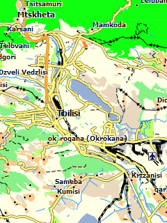 Грузия
 Карта Албании для GPS навигаторов Garmin, созданная из данных OpenStreetMap. Нанесены города страны, дорожная сеть, небольшое количество POI. Поддерживаются маршрутизация и адресный поиск.


