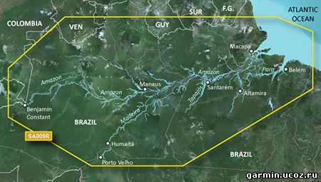
HSA009R - Amazon RiverDetailed coverage of the Amazon River from Benjamin Constant, Brazil to the Atlantic Ocean, the Madiera River to Porto Velho and portions of the Tapajos and Para Rivers.See your vessel's precise, on-chart position in relation to navaids, coastal features, anchorages, obstructions, waterways, restricted areas and more with this detailed marine mapping data. Also includes Safety Shading and Fishing Charts (in compatible units), smooth data transition between zoom levels, harmonious transition across chart borders and reduction of chart discontinuities in coverage areas.Features:Includes realistic navigation features showing everything from shaded depth contours and coastlines to spot soundings, navaids, port plans, wrecks, obstructions, intertidal zones, restricted areas, IALA symbols and more.Features smooth displays, including seamless transitions between zoom levels and more continuity across chart boundaries.Allows users to choose between standard 2-D direct overhead or 3-D "over the bow" map perspective to make chart reading and orientation easier.Provides Safety Shading (in compatible units), allowing mariners to enable contour shading for all depth contours shallower than user-defined safe depths.Provides Fishing Charts (in compatible units), allowing mariners to scope out bottom contours and depth soundings with less visual clutter on the display.Allows users to conveniently plan and organize routes, from your computer, before your trip with HomePort, compatible trip-planning software (sold separately).
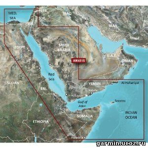
Coverage of the Red Sea and Gulf of Aden in their entirety, as well as the Indian Ocean including portions of the coasts of Somalia and Oman. Also includes coverage of the Mediterranean Sea from Beirut, Leb. to Alexandria Egy., including the Suez Canal and Gulf of Aqaba. Included in this overall general coverage are numerous detailed charts covering areas such as Jiddah, Sau., Djibouti, Dji., and Aden, Yem.
See your vessel’s precise, on-chart position in relation to navaids, coastal features and restricted areas with premium features found in this detailed marine mapping data. Includes all of the features of our BlueChart® g2 product, plus 3-D perspective above and below the waterline, Auto Guidance, high-resolution imagery, and aerial photos of ports, harbors, marinas and landmarks.
Shaded depth contours, coastlines, spot soundings, navaids, port plans, wrecks, obstructions, intertidal zones, restricted areas and IALA symbols.
Seamless transitions between zoom levels and more continuity across chart boundaries.
High resolution satellite imagery for a realistic view of the land and water.
Aerial photos of ports, harbors, marinas, waterways, navigational landmarks and other POIs.
Auto Guidance technology searches chart data to suggest the best passage to a destination.
MarinerEye view 3-D perspective for a quick, easy position fix.
FishEye view 3-D perspective for an underwater view of the sea floor.
Safety Shading* enables contour shading for all depth contours shallower than your defined safe depths.
Fishing Charts* to scope out bottom contours and depth soundings with less visual clutter on the display.
Plan and organize routes from your computer with HomePort™ (sold separately).
See your vessel’s precise, on-chart position in relation to navaids, coastal features, anchorages, obstructions, waterways, restricted areas and more with this detailed marine mapping data.
Shaded depth contours, coastlines, spot soundings, navaids, port plans, wrecks, obstructions, intertidal zones, restricted areas and IALA symbols.
Seamless transitions between zoom levels and more continuity across chart boundaries.
Standard 2-D direct overhead or 3-D "over the bow” map perspective for easy chart reading and orientation.
Safety Shading* enables contour shading for all depth contours shallower than your defined safe depths.
Fishing Charts* to scope out bottom contours and depth soundings with less visual clutter on the display.
Plan and organize routes from your computer with HomePort™ (sold separately).
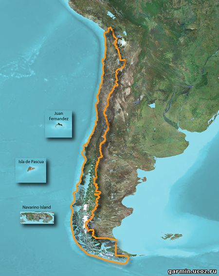
Descripción: Déjanos ser tu guía para actividades al aire libre en Chile. Estos mapas topográficos detallados muestran callejeros y mapas de ocio para actividades al aire libre, incluyendo contornos del terreno, elevaciones topográficas, cumbres, parques, líneas de costa, ríos, lagos, puntos geográficos y mucho más.
Proporciona mapas topográficos detallados para senderismo, excursionismo, ciclismo y otras actividades al aire libre.
Muestra contenido de carreteras con rutas e incluye indicaciones giro a giro.
Incluye una base de datos de puntos de interés, así como información sobre parques nacionales, senderos y caminos, lagos, ríos y arroyos.
•Includes realistic navigation features showing everything from shaded depth contours and coastlines to spot soundings, navaids, port plans, wrecks, obstructions, intertidal zones, restricted areas, IALA symbols and more. •Features smooth displays, including seamless transitions between zoom levels and more continuity across chart boundaries. •Includes high-resolution satellite imagery, when overlaid on the chart, provides the mariner with a realistic view of the land and water for unparalleled situational awareness. •Features aerial "real world” photos of ports, harbors, marinas, waterways, navigational landmarks and other points of interest, offering the mariner another powerful tool for navigating unfamiliar waters. •Includes Auto Guidance technology that searches chart data - tides, currents, marine services, coastal roads and points of interest - to suggest the best passage to a destination. •Offers MarinerEye view 3-D perspective, providing a bird's eye view from behind the boat showing the chart information for a quick, reliable and easy position fix. •Offers FishEye view 3-D perspective, providing an underwater view that visually represents the sea floor according to the chart's information. •Provides Safety Shading (in compatible units), allowing mariners to enable contour shading for all depth contours shallower than user-defined safe depths. •Provides Fishing Charts (in compatible units), allowing mariners to scope out bottom contours and depth soundings with less visual clutter on the display. •Allows users to conveniently plan and organize routes, from your computer, before your trip with HomePort™, compatible trip-planning software
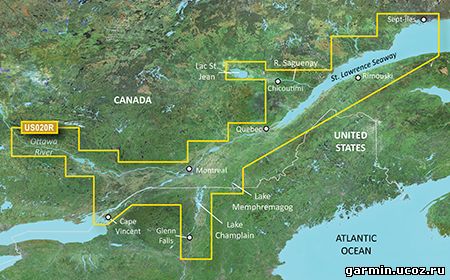
Covers the St. Lawrence River from Brockville, ON. to Sept-Îles, QC., including Montreal and Quebec. Also includes detailed coverage of Lake Champlain and Lac Saint-Jean, including Burlington, VT, Lac Memphémagog, Rideau River, the Ottawa River to Temiscaming, the Riviere Saguenay from Chicoutimi, QC. to the St. Lawrence River, and the Hudson River to Troy, NY.
 •Includes realistic navigation features showing everything from shaded depth contours and coastlines to spot soundings, navaids, port plans, wrecks, obstructions, intertidal zones, restricted areas, IALA symbols and more.


