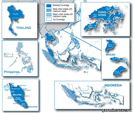
About Coverage Features detailed maps of major metropolitan areas in Singapore, Malaysia, Thailand, Indonesia, Hong Kong, Macau, Philippines, and Bali.
Includes motorways, national and regional thoroughfares and local roads throughout the country. Displays points of interest throughout the country, including restaurants, lodging, attractions, shopping and more. Gives turn-by-turn directions on your compatible device. Speaks street names (example: "Turn right on Main Street") Includes navigational features, such as turn restrictions, roundabout guidance, speed categories and more. Contains traffic data for compatible devices that use traffic receivers.
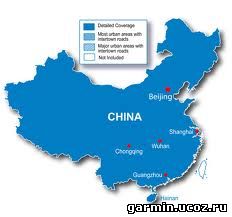
The official Garmin China maps have artificial shift (coordinate deviation) added for national security reasons. Using these maps on normal GPS devices or software will not display your actual location on the map. Instead, you will be a few hundred meters away from your actual location. Only GPS devices and software approved to be sold in the China market have additional built-in firmware or program to use these maps without shift problems. Even so, the saved waypoints, routes, tracks are still shifted. Neither can topo maps be used with them.
Venus is a series of maps derived from the official Garmin China maps but with shifts corrected. Nothing but the coordinates are changed, so all road, POI info, as well as routing, searching capabilities remain intact. Saved waypoints, routes, tracks will have no shift problems. Compatible with topo maps too. These maps can be used on any regular Garmin GPS devices and software as other maps. However, some maps are in Chinese language only and require Chinese support on your device to display and search in Chinese.
Disclaimers: 1. No guarantee or warranty is given. Use at your own risk. 2. The correction is not perfect yet. A few places may have a gap between roads.
For this 2011.12 map: All road and POI names are in simplified Chinese. This map should fix the search problem of 2011.11 map that many users had.
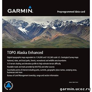
Provides topographic maps of Alaska, comparable to 1:24,000 and 1:63,360 scale USGS maps. Contains 24K coverage in 3 main cities in Alaska, including Anchorage, Juneau and Fairbanks. All other areas in Alaska contain 63K coverage. Features national, state and local parks, forests, recreational and wildlife area boundaries as well as routable roads for accurate directions to your destination. Includes searchable urban and wilderness points of interest, such as geographical place names, camping areas and businesses. Displays 3-D terrain shading and digital elevation model (DEM) shaded relief on compatible devices to help estimate terrain difficulty. Features Bureau of Land Management township, range and section information
About Coverage Features detailed 24K topographic maps in Anchorage, Juneau and Fairbanks; All other areas in Alaska contain detailed 63K topographic maps
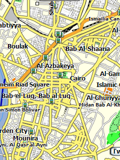
Карта Египта, созданная из данных OpenStreetMap, для GPS навигаторов Garmin. Нанесены дороги страны, населённые пункты, гидрография, довольно приличное количество ПОИ. Показана карта Каира с названиями улиц. Поддерживаются адресный поиск и автоматическая прокладка маршрута.
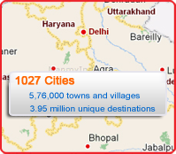
All India Street level maps for 1027 cities across India. Number of POIs/Unique destinations increased to 3.95 Million which are connected by 1.05 Million km Road Augmented Reality with 3-D landmarks and 2-D building foot prints across Mumbai and Delhi House Map Data of 18 cities.
Includes!
Street level turn-by-turn instructions in 125 tourist cities
Driving directions to 30,000 tourist locations
Find facilities like nearest airport, railway station, bus stand, etc. for easy commute within tourist cities
Find all major tourist spots in the city and create your own itinerary using the 'via' points feature
Find details on hotels (classified as budget and premium), eating joints (classified as per cuisine) and tourist offices in these cities.
Tour Southeast Asia Navigate the streets of Southeast Asia with confidence. City Navigator Southeast Asia NT provides detailed road maps and points of interest for your device, so you can navigate with exact, turn-by-turn directions to any address or intersection. Route to restaurants, gas stations, lodging, attractions and more.
Includes detailed maps of major metropolitan areas in Singapore, Malaysia, Thailand, Indonesia, Hong Kong, Macau, Philippines, and Bali.
Includes motorways, national and regional thoroughfares and local roads.
Displays points of interest throughout the country, including restaurants, lodging, attractions, shopping and more.
Gives turn-by-turn directions on your compatible device.
Provides additional junction views and 3-D landmarks on your compatible unit.
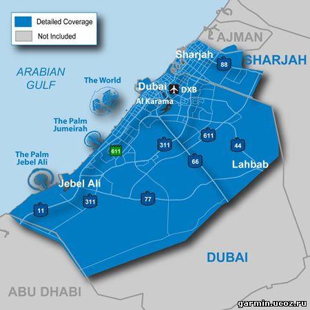
Navigate the big city like your hometown with cityXplorer for your street navigator. This detailed city map provides the latest roads and points of interest for the metropolitan area, plus enhanced pedestrian navigation¹ — street directions that let you use public transportation to get you where you need to go.
Get the Map Data You Need
cityXplorer includes the same detailed street data and information found in City Navigator® maps. This convenient download puts the latest street maps and most up-to-date points of interest on your device, so you'll have updated local information for shopping, restaurants, hotels, entertainment, parking and so much more Navigate Public Transit.
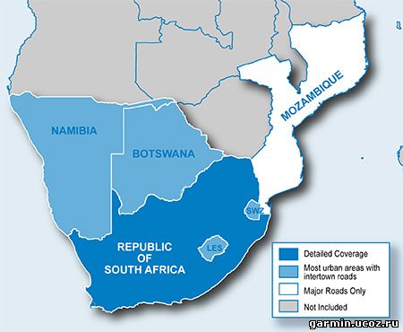
Includes more than 720,000 km (450,000 mi) of roads, including motorways, national and regional thoroughfares and local roads, in South Africa. Displays more than 200,000 points of interest throughout the country, including restaurants, petrol/gasoline stations, lodging, attractions, railways and more. Gives turn-by-turn directions on your compatible device. Speaks street names (example: "Turn right on Main Street") Includes navigational features, such as turn restrictions, roundabout guidance, speed categories and more.

 Обновилась базовая карта для Garmin, из улучшений: более быстрая прокладка маршрута и пр. муть, у кого проблема с роутингом - ставить обязательно.