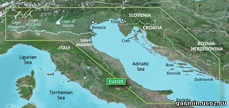
See your vessel’s precise, on-chart position in relation to navaids, coastal features, anchorages, obstructions, waterways, restricted areas and more with this detailed marine mapping data.
Shaded depth contours, coastlines, spot soundings, navaids, port plans, wrecks, obstructions, intertidal zones, restricted areas and IALA symbols.
Seamless transitions between zoom levels and more continuity across chart boundaries.
Standard 2-D direct overhead or 3-D “over the bow” map perspective for easy chart reading and orientation.
Safety Shading* enables contour shading for all depth contours shallower than your defined safe depths.
Fishing Charts* to scope out bottom contours and depth soundings with less visual clutter on the display.
Plan and organize routes from your computer with HomePort™ (sold separately).
Coverage Detailed coverage of the Adriatic Sea coast from Trani to Monfalcone, IT southeast to Dubrovnik, HR. Includes detailed coverage of Lago Maggiore, Lago di Como, Lago d'Iseo, Lago di Garda and the Po River from the Adriatic to the Ticino River confluence.
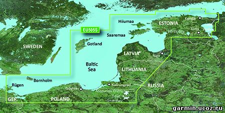
See your vessel’s precise, on-chart position in relation to navaids, coastal features, anchorages, obstructions, waterways, restricted areas and more with this detailed marine mapping data.
Shaded depth contours, coastlines, spot soundings, navaids, port plans, wrecks, obstructions, intertidal zones, restricted areas and IALA symbols.
Seamless transitions between zoom levels and more continuity across chart boundaries.
Standard 2-D direct overhead or 3-D “over the bow” map perspective for easy chart reading and orientation.
Safety Shading* enables contour shading for all depth contours shallower than your defined safe depths.
Fishing Charts* to scope out bottom contours and depth soundings with less visual clutter on the display.
Plan and organize routes from your computer with HomePort™ (sold separately).
Coverage Coverage of the coasts of Germany, Poland, Russia, Lithuania, Latvia and Estonia from Rügen, DE to Narva-Jõesuu, EE. Detailed coverage includes the Szczecin Lagoon, Bornholm, the Vistula Lagoon, Kaliningrad, Gotland, the Gulf of Riga, Saaremaa, Hiiumaa, Lake Peipus, and the Mazurian and other Polish lakes including Lake Jeziorak, Lake Lanskie and Lake Sniardwy.
See your vessel’s precise, on-chart position in relation to navaids, coastal features, anchorages, obstructions, waterways, restricted areas and more with this detailed marine mapping data.
Shaded depth contours, coastlines, spot soundings, navaids, port plans, wrecks, obstructions, intertidal zones, restricted areas and IALA symbols.
Seamless transitions between zoom levels and more continuity across chart boundaries.
Standard 2-D direct overhead or 3-D "over the bow” map perspective for easy chart reading and orientation.
Safety Shading enables contour shading for all depth contours shallower than your defined safe depths.
Fishing Charts to scope out bottom contours and depth soundings with less visual clutter on the display.
Plan and organize routes from your computer with HomePort™ (sold separately).
Coverage Coverage of the Dardanelles, the Sea of Mamara, the Bosporus, the Black Sea, the Dnieper River as far as Kherson, the Bug River as far as Nikolayev and the Sea of Azov.
Detailed coverage includes Burgas and Varna, Bulgaria; Constanta, Romania; Odessa, Nikolayev, Kherson, Sevastopol', Kerch' and Mariupol, Ukraine; Taganrog, Yeysk, Temryuk, Novorossiysk, Poti and Batumi, Russia; Hopa, Giresun, Samsun, Zonguldak, Eregli, Istanbul, Bandirma and Canakkale, Turkey. FID: 3247, PID: 1, RID: 17, VID: 3
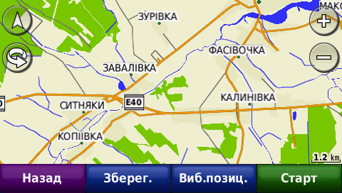
Тип раздаваемого файла: Карта Формат: .IMG FID: 575 Платформа: Garmin Версия: 2013.06 Дата выпуска: март 2014 Разработчик: ООО «Карт Бланш Украина» Офсайт:http://www.gpsmap.com.ua/ru/products/software/cbunt/ Язык интерфейса: украинский, русский и английский Лицензия: карта разблокирована
See your vessel’s precise, on-chart position in relation to navaids, coastal features, anchorages, obstructions, waterways, restricted areas and more with this detailed marine mapping data.
Shaded depth contours, coastlines, spot soundings, navaids, port plans, wrecks, obstructions, intertidal zones, restricted areas and IALA symbols.
Seamless transitions between zoom levels and more continuity across chart boundaries.
Standard 2-D direct overhead or 3-D “over the bow” map perspective for easy chart reading and orientation.
Safety Shading* enables contour shading for all depth contours shallower than your defined safe depths.
Fishing Charts* to scope out bottom contours and depth soundings with less visual clutter on the display.
Plan and organize routes from your computer with HomePort™ (sold separately).
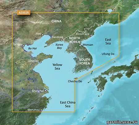
Coverage General coverage of the Chinese coast from Wenzhou to Dandong; the South Korean coast in its entirety; the full west coast of North Korea and the east coast south of Kimch'aek. Included in this overall general coverage are numerous detailed charts covering areas in China such as Shanghai, Qingdao, and Dalian; and also Nampo, N.Kor., and Pusan, S. Kor
See your vessel’s precise, on-chart position in relation to navaids, coastal features, anchorages, obstructions, waterways, restricted areas and more with this detailed marine mapping data.
Shaded depth contours, coastlines, spot soundings, navaids, port plans, wrecks, obstructions, intertidal zones, restricted areas and IALA symbols.
Seamless transitions between zoom levels and more continuity across chart boundaries.
Standard 2-D direct overhead or 3-D “over the bow” map perspective for easy chart reading and orientation.
Safety Shading* enables contour shading for all depth contours shallower than your defined safe depths.
Fishing Charts* to scope out bottom contours and depth soundings with less visual clutter on the display.
Plan and organize routes from your computer with HomePort™ (sold separately).
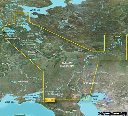
Coverage This Cyrillic data card details main channel coverage of the major river systems and lakes of westernRussia. Detailed coverage includes the Don R. from the Sea of Azov (Azovskoe More) to the Tsimlyanskoe Reservoir (Tsimlyansk Vodokhranilishche); the Volga-Don Canal (Volgo-Donskoy Kanal) to the Volga R. which is shown in its entirety; the Kama R. from Tyul'kino to the Volga R.; the Oka R. from Kaluga to its junction with the Moskva R; the Sheksna R. in its entirety; Lake Beloe (Beloye Ozero); the Volga-Baltic Canal (Volgo-Baltiyskiy Kanal); Lake Onega (Onezhskoe Ozero); the Svir R. to Lake Ladoga (Ladozhskoye Ozero); and the Neva R. to St. Petersburg (Sankt-Peterburg). Also included are the Volga-Baltic Waterway including the Rybinsk Reservoir (Rybinskoye Vodokhranilishche), the entire White Sea-Baltic Canal, Lakes Onega (Onezhskoe), Ladoga (Ladozhskoye), and Beloe (Beloye).
Навител Навигатор - навигационная система с поддержкой пробок и самыми подробными картами России, Европы, Турции и Латинской Америки.
Навигационные карты России, Украины, Республики Беларусь, Албании, Аргентины, Белиза, Боснии и Герцеговины, Болгарии, Венгрии, Венесуэлы, Гватемалы, Гондураса, Греции, Дании, Казахстана, Киргизской Республики, Коста-Рики, Литвы, Латвии, Македонии, Мексики, Молдовы, Никарагуа, Новой Каледонии, Норвегии, Панамы, Польши, Румынии, Сальвадора, Сербии, Словакии, Турции, Узбекистана, Финляндии, Хорватии, Швеции, Черногории, Чехии, Эстонии.
+ Высокодетализированные карты + Мгновенное построение маршрутов + Бесплатные онлайн-сервисы "Навител.Пробки", "Навител.Друзья", "Навител.События", "Навител.SMS", "Навител.Погода", Динамические POI + Автоматическое обновление карт из программы (бесплатно!) + Обширная база POI + 3D развязки + SpeedCam + Удобные виды поиска объектов на карте + Настраиваемый интерфейс + Android 1.6-4.0
GeoNET - GPS навигатор нового поколения, который позволяет использовать навигационные карты от разных поставщиков и производителей: ★ Карты OSM – бесплатное глобальное картографическое покрытие от проекта OpenStreetMaps с систематическими обновлениями и переизданиями. ★ Карты HERE – платная коллекция карт от NOKIA. ★ Карты навигационной службы СитиГИД с «пробками» и регулярными корректурами. ★ Карты национальных производителей.
Данная программа является родным братом, полюбившегося многим навигатора , знакомый интерфейс с улучшенной производительностью и плавностью в работе! GeoNET, явлеяется новым продуктом, который авторы обещают развивать и совершенствовать, при этом будет и дальше поддерживаться и обновляться!
Дата выпуска: 20.03.2014 г. Версия: 8.0.427 Разработчик: MIT GEOMATICS LTD Сайт разработчика:Здесь Язык интерфейса: Русский Состояние: взлом, без проверки лицензии, сама оболочка платная, куплена и отвязана от маркета, то есть карты скачанные самостоятельно или ранее скачанные для ситигид работают, кроме того, в самой программе есть возможность скачать триальные карты, велика вероятность того, что и после пробного периода карты будут работать в паре со взломанным маркетом! Системные требования: 1.6 и выше
Garmin - City Navigator Southern Africa NT 2014.30 Requirements: garmin devices Overview: Navigate the streets with confidence. This product provides detailed road maps and points of interest for your device, so you can navigate with exact, turn-by-turn directions to any address or intersection.
Includes more than 1.04 million km (649,000 mi) of roads, including motorways, national and regional thoroughfares and local roads, in South Africa. Displays more than 330,000 points of interest throughout the country, including restaurants, petrol/gasoline stations, lodging, attractions and railways. Gives turn-by-turn directions on compatible devices. Speaks street names (example: "Turn right on Main Street"). Includes navigational features, such as turn restrictions, roundabout guidance and speed categories. Contains traffic data for compatible devices that use traffic receivers.
Features coverage of Angola, Botswana, Lesotho, Malawi, Mozambique, Namibia, Swaziland and Zimbabwe, with detailed coverage throughout the Republic of South Africa
FID 3337
в архиве: unlocked gmap folder unlocked 3d jcv file
 Карта Украины от Open Street Map за 24 апреля данного года. Поиск на украинском языке. Карта разблокирована.
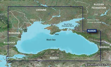
 Garmin - City Navigator Southern Africa NT 2014.30


