Категории раздела
Карты РОССИИ [175]
Карты Украины [42]
Карты Европы [103]
Карты стран СНГ [35]
Карты Сев. Америки [0]
Остальные карты [97]
Карты для Навитела [319]
Карты для City Guide [59]
Карты для Rusa [5]
Карты для GisRX [11]
Карты для ГисРусса [2]
Карты для IGO [12]
Twitter
Новые файлы
[15.03.2015][Карты Европы]
City Navigator Europe NT Unicode 2015.40 [All] (1)
[15.03.2015][Garmin MOBILE]
Навител Навигатор [Android] - v.9.5.30 (1)
[08.03.2015][Карты для Навитела]
Навител Навигатор все официальные карты за 2015 (0)
[28.02.2015][Garmin MOBILE]
Навител Навигатор [Android] - v.9.5.0 (2)
[27.02.2015][POI]
Garmin Cyclops Safety Cameras - EU / AU / NA /ZA /RU /ME (24.02.15) (1)
[25.02.2015][POI]
Сборник SpeedcamRu ByLuk (камеры, радары) по Украине от 23.02.2015г. (1)
[25.02.2015][POI]
Сборник SpeedcamRu ByLuk (камеры, радары) по России от 23.02.2015 (2)
[22.02.2015][Карты РОССИИ]
OpenStreetMap Russia: обновление 28.01.15, Россия + Деление по Округам с поиском до дома [28.01.15] (2)
[22.02.2015][Карты Европы]
Bulgaria OFRM Geotrade 2015 Q1 (0)
[18.02.2015][Карты Украины]
City Navigator Europe NT Unicode 2015.30 [Ukraine] (1)
[18.02.2015][Карты Европы]
City Navigator Europe NT Unicode 2015.30 (1)
[26.01.2015][Карты РОССИИ]
City Navigator Russia NT Navicom 2015.40 (34)
[06.01.2015][Карты Украины]
City Navigator Europe NT Unicode 2015.30 [Ukraine] (1)
[06.01.2015][POI]
Garmin Cyclops Safety Cameras - EU / AU / NA /ZA /RU /ME (31.12.14) (0)
[06.01.2015][Карты РОССИИ]
City Navigator Russia NT 2015.30 Navicom [unl.3d/jcv/g2s/sid/db/md2] (4)
Форум
  • ВЗЛОМ ПОЧТЫ БЕЗ ПРЕДОПЛАТЫ АНОНИМНО БЕЗ СМЕНЫ ПАРОЛЯ (12)
  • Профессиональный взлом. Анонимно. Быстро. Дёшево. (0)
  • Услуги по взлому! Без предоплаты! Ответ в течении 10 минут. (0)
  • ВЗЛОМ НА ЗАКАЗ БЕЗ ПРЕДОПЛАТЫ (0)
  • ВЗЛОМ СТРАНИЦЫ В ОДНОКЛАССНИКАХ (1)
  • Главная » Файлы » файлы » Карты РОССИИ

    HRU001R - Russian Inland Waterways v2012 (v13.50)
    12.06.2012, 19:32
    Version: 2012
    Released: Feb, 2012
    Part Number: 010-D0820-00 

    See your vessel’s precise, on-chart position in relation to navaids, coastal features, anchorages, obstructions, waterways, restricted areas and more with this detailed marine mapping data. Also includes Safety Shading and Fishing Charts (in compatible units), smooth data transition between zoom levels, harmonious transition across chart borders and reduction of chart discontinuities in coverage areas.
    • Includes realistic navigation features showing everything from shaded depth contours and coastlines to spot soundings, navaids, port plans, wrecks, obstructions, intertidal zones, restricted areas, IALA symbols and more.
    • Features smooth displays, including seamless transitions between zoom levels and more continuity across chart boundaries.
    • Allows users to choose between standard 2-D direct overhead or 3-D "over the bow" map perspective to make chart reading and orientation easier.
    • Provides Safety Shading (in compatible units), allowing mariners to enable contour shading for all depth contours shallower than user-defined safe depths.
    • Provides Fishing Charts (in compatible units), allowing mariners to scope out bottom contours and depth soundings with less visual clutter on the display.
    • Allows users to conveniently plan and organize routes, from your computer, before your trip with HomePort™, compatible trip-planning software (sold separately).


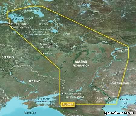
    This Cyrillic data card details main channel coverage of the major river systems and lakes of western Russia. Coverage includes the Don R. from the Sea of Azov (Azovskoe More) to the Tsimlyanskoe Reservoir (Tsimlyansk Vodokhranilishche); the Volga-Don Canal (Volgo-Donskoy Kanal) to the Volga R. which is shown in its entirety; the Kama R. from its junction with the Vyatka R. to the Volga R.; the Oka R. from Kaluga to its junction with the Moskva R; the Sheksna R. in its entirety; Lake Beloe (Beloye Ozero); the Volga-Baltic Canal (Volgo-Baltiyskiy Kanal); Lake Onega (Onezhskoe Ozero); the Svir R. to Lake Ladoga (Ladozhskoye Ozero); and the Neva R. to St. Petersburg (Sankt-Peterburg). Detailed coverage features the Volga-Batic Waterway, including the Rybinsk Resevior (Rybinskoye Vodokhranilishche); Lakes Onega (Onezhskoe), Ladoga (Ladozhskoye), and Beloe (Beloye). 

    FID: 2538


    Категория: Карты РОССИИ | Добавил: Garmin | Теги: HRU001R - Russian Inland Waterways
    Просмотров: 4956 | Загрузок: 911 | Комментарии: 1 | Рейтинг: 0.0/0 |
    Всего комментариев: 0
    Добавлять комментарии могут только зарегистрированные пользователи.
    [ Регистрация | Вход ]
    Суббота, 27.04.2024, 06:47
    Приветствую Вас Гость
    Форма входа
    Поиск
    Тэги

    Для красивого отображения этого блока требуется Flash Player 9 или выше.

    Статистика

    Партнеры
    Rambler's Top100 AllTheBestFiles - Развлекательный портал
    Реклама